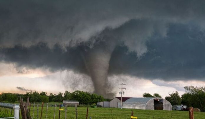
A violent storm system has been raging across the central United States since Monday, unleashing a barrage of tornadoes, flooding rains, and destructive hail. Over 8 million Americans were under severe weather warnings as the storms tore through Missouri, Oklahoma, Texas and beyond. This multi-day severe weather event is forecast to continue its brutal onslaught through Wednesday across a wide swath of the nation.
Day 1: Chaos and Destruction
The opening salvo from this powerful storm began on Monday evening across Texas, Illinois, and Oklahoma. Residents shared shocking videos on social media of cracked windshields and hail the size of tennis balls pummeling anything in its path. Trees were downed, homes damaged, and power lines torn apart leaving many in the dark.
“It was like a bomb went off,” said Sara Jenkins of Dallas after her home’s windows were shattered by the massive hailstones. “We huddled in the bathroom hoping and praying it would pass. The noise was absolutely deafening.”
Vehicles were not spared from nature’s bombardment either. Numerous multi-car pileups occurred on highways after dirt and debris were whipped up by dust storms, blinding drivers. First responders worked through the night extricating people from the tangled wrecks.
“I couldn’t see a thing in front of me,” recalled truck driver Miguel Ramirez who was caught in one of the pileups near Oklahoma City. “Then I just started plowing into other cars and trucks. It was like a demolition derby out there.”
Day 2: No End in Sight
Though the first night of turmoil has passed, the nightmare continues for millions today. After lashing Texas, Illinois and Oklahoma with its high winds, tornadoes and hail, the storms re-intensified overnight. They are now extending from northern Indiana and Ohio down through western Pennsylvania, West Virginia and Kentucky.
The National Weather Service’s Storm Prediction Center has issued a high risk for more tornadoes across a corridor stretching from southeastern Indiana through Ohio and into portions of Kentucky, West Virginia and Pennsylvania. Over 50 million Americans are facing threats from these storms through Wednesday.
Major metro areas in the crosshairs include Memphis, Nashville, Louisville, Cincinnati, Columbus and Pittsburgh among others. Schools, businesses and places of worship have been closed across the broad risk zone to keep people off the roads and indoors.
“We are preparing for the worst but praying for the best,” said Nashville Mayor John Cooper as the city opened emergency shelters. “These storms have been terrorizing communities for over 24 hours now. Their force and unpredictability is extremely concerning.”
Widespread Power Outages
Among the hardest hit areas so far has been Memphis, Tennessee where over 14,000 customers remain without power as of mid-morning Tuesday. At one point earlier in the day, 38,000 homes and businesses went dark after high winds downed trees and power lines.
Utility crews have been working around the clock making repairs, but estimate it may still be hours or days before power is fully restored across the city’s electrical grid. Traffic lights are out, hospitals running on generators, and stoplights are dark exacerbating the chaos.
“We had drawn down our inventories in preparation for these storms based on the forecasts,” said Jerry Rameriz, President of Memphis Light, Gas and Water. “But nothing could really prepare us for the sheer magnitude of outages all at once. It’s going to take a tremendous effort from our crews to untangle this mess.”
Further north in Bloomington, Indiana, the storm hit with a vengeance earlier today. Footage captured by WeatherNation showed a severe thunderstorm dousing the city, with frequent lightning illuminating the skies amid the driving rain.
Hail So Large It Was Mistaken for Snowfall
Perhaps some of the most bizarre impacts occurred overnight when parts of Texas experienced hailstones so large, that they were initially mistaken for snowfall. Social media videos depicted accumulated piles of frozen spheres in streets and on lawns, resembling a winter wonderland scene.
“The Wake Up Weather crew was baffled when we first saw those videos,” said meteorologist Tara Petersen. “It wasn’t until a few seconds in you realize it’s simply massive hailstones, not snow. I don’t think I’ve ever seen hail that large from a single thunderstorm before!”
Some of the monstrous hail was reported to be 4.5 inches in diameter, roughly the size of a grapefruit. At those dimensions, the weighty ice chunks can easily shatter windshields, dent vehicles, and potentially cause serious injury to anyone caught outside.
Looking Ahead
Unfortunately, there is no immediate end in sight to this multi-day weather calamity. Additional severe thunderstorms, flash flooding and isolated tornadoes are expected through Wednesday across a region home to over 50 million people.
The storms will push eastward into the Appalachians, mid-Atlantic and even New England over the next 24-48 hours before finally starting to wind down late Wednesday. However, any additional training of thunderstorms over the same areas could renew significant flood risks.
Federal emergency resources are already being mobilized and positioned for additional search, rescue and recovery efforts if needed. Residents across the threatened zones are urged to remain vigilant, heed all warnings from officials and brace for additional rounds of potentially life-threatening weather through mid-week.
Nature’s fury is on full display, leaving terrified communities to shelter in place and pick up the pieces once the cyclone of storms finally passes. Tragically, extreme “once in a generation” events like these are becoming increasingly common in our rapidly warming world.

